50 tools · official UK data sources
Property Tools
HouseCheckup provides 50 property tools powered by official UK government data sources. Check flood risk, EPC rating, crime, schools, and more at postcode-area level, in your browser, no card or signup.
Type the full address with its postcode to go straight to your report options. Try .
- 65+ official sources
- Emailed within 24 hours, usually faster
- Sources and coverage gaps named
- One-off payment, no subscription
What the report looks like inside
See the full sample →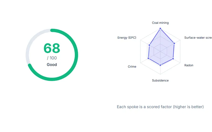 IQ Score and the factors behind it
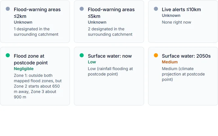 Flood risk at the postcode point
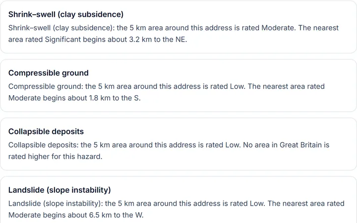 Six ground hazards, rated for the area
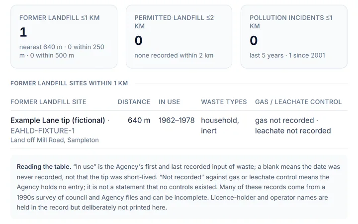 Landfill, permits and incidents nearby
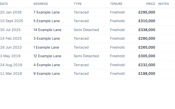 What homes here sold for
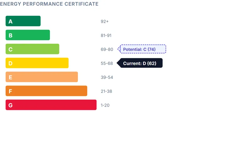 The energy rating, now and after upgrades
Illustrative sample · fictional address · cut from the sample report as it prints
Conservation Area Checker
Check a postcode for a conservation area and the distance to its boundary, listed buildings within 700 m with grades, protected trees and Article 4. England..
Should I Buy This House?
Explore available official flood, ground, crime and energy indicators for a postcode. Source coverage varies; a score is not a buying recommendation..
House Check
Run a house check on any UK postcode: flood, coal mining, radon, subsidence and crime readings from official government sources, scored 0–100 on screen, no signup. The paid report adds available flood, ground, crime, energy and sale-record context.
Flood Risk Checker
Flood risk checker by postcode: EA flood zone, recorded floods within 250 m, nearby defences and their condition, and the 2050s climate allowance. England..
Flood History Check
Check if a postcode has flooded before: Environment Agency recorded flood events, the flood zone, and nearby flood defences with their condition. England..
Landfill Check
Is the house near a former landfill? Enter a postcode to see historic landfill sites within 1 km, the nearest site, its years in use and waste types..
Storm Overflow Check
Enter a postcode to find the nearest monitored storm overflow and its reported sewage spills and hours for 2023–2025, from the Environment Agency return..
Coastal Erosion Check
Is the property on a mapped coastal-erosion frontage? Enter a postcode for the Shoreline Management Plan policy to 2055 and 2105 from the EA erosion map..
EPC Checker
EPC finder: enter a postcode to see the certificates lodged there (England & Wales), the A–G band, potential band, floor area and upgrades. Scotland linked..
Property Age Checker
Find out roughly when a house was built. Enter a postcode for its construction era from the official EPC register, and what that age means for damp, wiring and asbestos before you buy..
Crime Rate Checker
Check the crime rate for any UK postcode. Street-level crime by category from official police.uk data: burglary, vehicle crime, anti-social behaviour and more.
House Valuation Check
How much is my house worth? Get an honest indicative valuation by postcode: an area estimate from HM Land Registry sold prices and the UK House Price Index, plus your property's exact last-sold price. Not a certified valuation.
Area Checker
Explore available flood, ground, crime and energy indicators at a postcode. Source coverage varies; missing checks remain visible..
Subsidence Risk Checker
Is the house on shrinking clay or old mine workings? Enter a postcode for the British Geological Survey's subsidence ratings and the coal-mining risk check, free, before you offer..
Radon Risk Checker
Radon gas levels by postcode: the UKHSA indicative map class for the area, what the 200 Bq/m³ Action Level means, how to test a home and what a fix costs..
Air Quality Checker
Check air quality for any UK postcode. HouseCheckup shows PM2.5 and NO₂ levels from DEFRA data.
Noise Pollution Checker
Will road noise keep you up? Check modelled day and night road-noise levels for any England postcode from the government's noise maps, free, no signup..
Coal Mining Risk Checker
Free coal mining postcode screen. Understand a development-risk flag, CON29M searches and the different role of a Coal Mining Risk Assessment..
Planning Applications
Search planning applications near any England or Wales property. HouseCheckup shows recent and pending applications from 350+ local authorities.
School Finder
Find schools near any England or Wales property with Ofsted ratings. HouseCheckup shows primary and secondary schools with distance, rating, and performance data.
Stamp Duty Calculator
Stamp duty calculator for England & Northern Ireland. Work out your SDLT bill for first-time buyers, home movers and additional properties using the latest 2026 rates and thresholds.
Second Home Stamp Duty Calculator
Work out the stamp duty on a second home or holiday home. The 5% surcharge applies to every band: on a £300,000 second home that's £20,000.
Buy-to-Let Stamp Duty Calculator
Work out buy-to-let stamp duty. BTL purchases pay 5 points on top of every band: £15,000 on a £250,000 buy-to-let.
True Cost of Owning a House
Work out the true cost of owning a house in the UK: mortgage, council tax, energy, service charge, ground rent and insurance in one monthly figure. Instant..
Service Charge Tribunal Decision Check
Search published England property-tribunal decisions by postcode. Verify the building, parties, date and outcome; no result is not a management clearance..
Property Red Flags
Check property red flags before buying. HouseCheckup scans flood risk, subsidence, radon, contamination, planning issues, and more: 15+ checks from official sources.
Mortgage Calculator
UK mortgage repayment calculator: monthly payment, total repaid and total interest over the term, plus the repayment vs interest-only difference. Standard amortisation arithmetic, no signup..
Affordability Calculator
Affordability calculator: a realistic borrowing RANGE from the 4–4.5× income rule of thumb lenders start from, adjusted for your outgoings, plus the price bracket your deposit puts you in. A planning figure, not a lender decision..
Buying Costs Calculator
Add up every one-off cost of buying a house in England & NI: exact stamp duty, your council's real local-authority search fee where we've verified it, plus conveyancing, survey, Land Registry and removals. Itemised on screen..
Rental Yield Calculator
Calculate gross and net rental yield for any England or Wales property. HouseCheckup shows yield, cash-on-cash return, and annual profit.
Rent vs Buy Calculator
Compare the cost of renting vs buying a home in the UK. HouseCheckup calculates total costs over time including mortgage, rent increases, and capital growth.
Moving Costs Calculator
Estimate the total cost of moving house in the UK. HouseCheckup covers removals, cleaning, mail redirection, and setup costs.
Lease Extension Calculator
Lease extension calculator for England & Wales. Estimate the statutory premium as a LOW–HIGH range using the LRHUDA 1993 formula, with the 80-year marriage-value cliff shown.
Council Tax Band Checker
Council tax band checker: enter a postcode in England, Wales or Scotland for every band's 2026/27 charge (A–H; A–I in Wales), plus the official VOA/SAA link for the home's band..
Pylons & Power Lines Check
Check for pylons, overhead power lines and substations near a property and what they mean for value, mortgages, EMF health concerns and the wayleave on your title. OpenStreetMap power-infrastructure data..
Tree Preservation Order (TPO) Check
Check for a Tree Preservation Order (TPO) near a property and what it means: what you can and can't do, conservation-area tree rules, penalties for unlawful work, and how it affects building and extensions..
Listed Building Check
Check whether a property is a listed building and what the grade (I, II*, II) means: listed building consent, what you can and can't change, VAT and repair costs, mortgages and insurance. Historic England NHLE data..
Water Quality & Sewage Check
Check sewage discharges and river or bathing water quality near a property using Environment Agency data: storm overflows, spill hours, river ecological status and bathing-water classifications. What it means for buyers..
Postcode Checker
Check any UK postcode: recorded crime, HM Land Registry sold-price median, EPC mix and an Environment Agency flood flag, from official open data, no signup, no subscription. A postcode-area reading, with the house-level report a one-off away..
Street Check
Run a free street check by postcode: recorded crime, what homes on the street actually sold for, the EPC mix and a flood flag, all from official sources. No signup..
Should I Offer? Asking-Price Check
Enter an address and asking price. We check it against HM Land Registry sold prices for comparable homes nearby and show whether it sits ABOVE, WITHIN or BELOW the local evidence: a sold-price based range, not a valuation.
First-Time Buyer Stamp Duty Calculator
Work out your stamp duty as a first-time buyer in England & Northern Ireland, with relief applied automatically: no SDLT on the first £300,000, 5% to £500,000. Band-by-band working and the exact saving shown.
House Price per Square Metre by Postcode
See £ per square metre for recent sold homes near any postcode. We join real HM Land Registry sold prices to EPC floor areas (England & Wales) so you can compare an asking price against what homes actually fetch per square metre.
Article 4 Direction Checker
Check whether a postcode sits in an Article 4 Direction area, using the official planning.data.gov.uk map. Article 4 removes permitted-development rights, including converting a house to a small HMO without full planning permission.
HMO Licence Checker: Mandatory Rules + Article 4
Check whether a let needs a mandatory HMO licence (5+ occupants in 2+ households) and whether the postcode sits in an Article 4 area that restricts HMO conversion. England & Wales mandatory rules plus a live Article 4 check; council additional/selective schemes are signposted to your local authority.
New Build Snagging Checklist Tool
A room-by-room snagging checklist for new-build homes: every room, windows and doors, kitchen, bathrooms, heating and electrics, loft, garage and outside, plus the paperwork to collect before you sign off. Unlock it on screen and get a printable PDF copy emailed to take to your handover..
House Survey Cost Calculator
Calculate a house survey budget from a written quote, agreed extras and VAT. Compare RICS levels and the scope to discuss with your surveyor..
Limited Company Stamp Duty Calculator
Work out stamp duty for a limited company or SPV buying residential property. Companies pay the 5-point higher rates on every purchase, even the first, with a £500k+ flat-15% edge case.
Freehold or Leasehold Checker
Freehold or leasehold? See the tenure recorded on sales at a postcode, the street pattern and tribunal decisions, plus the £7 route to confirm a title..
Property Owner Check
Who owns a property in England, Wales or Scotland? The £7 title register route, what it shows, company and overseas owners, and what sale records reveal..
Want the full picture?
These tools check individual data points. The HouseCheckup Complete report combines 15+ checks from official sources into one full PDF report with a composite IQ Score, for just £24.99.
What's in the report
A full PDF report bringing together available property risks, price history and neighbourhood context. A Complete report runs to 33 numbered sections in seven parts; Lite is the safety & environment part with the closing checklist and sources.
- The verdict
- Safety & environment
- Value & market
- The home & energy
- Area & lifestyle
- Written for the address
Price History
Every recorded sale on the street, with area price context.+5 checksShow detailsHide detailsHM Land Registry street and postcode transactions, plus local UK House Price Index context where available: every recorded sale on the street, newest first, with tenure, property type and new-build flags, typical price by property type, and how the local authority, region and nation compare
- Every recorded sale on the street and postcode
- Tenure, property type and new-build flags
- Typical price by property type
- Local authority, region and nation compared
- Local UK House Price Index context
Prints in: Value & market
Energy & Carbon
The whole energy certificate, running costs and improvements.+7 checksShow detailsHide detailsMatched EPC band, potential improvements, estimated energy costs and carbon emissions where a certificate is available. You get the whole certificate: every element the assessor rated with its star ratings, running costs now and after the costed improvements, rooms, glazing, validity, plus modelled solar potential
- Matched EPC band
- Every rated element with its star ratings
- Running costs now and after improvements
- Costed potential improvements
- Carbon emissions
- Rooms, glazing and validity
- Modelled solar potential
Prints in: The home & energy
Flood & Climate Risk
Flood maps, recorded flooding, defences and future scenarios.+8 checksShow detailsHide detailsFlood maps and recorded extents, with available future surface-water flood scenarios and coastal erosion data; coverage varies by nation. Included: every flood-warning area within 2 km and 5 km named, recorded flood events, river-flow climate allowances, Flood Re eligibility, and every flood defence within about 1.5 km with its condition
- Flood maps and recorded extents
- Future surface-water flood scenarios
- Coastal erosion data
- Flood-warning areas within 2 km and 5 km
- Recorded flood events
- River-flow climate allowances
- Flood Re eligibility
- Flood defences within about 1.5 km
Prints in: Safety & environment
Ground & Environmental
Ground hazards, radon, coal mining, noise and air quality.+7 checksShow detailsHide detailsBGS area hazard bands, radon potential, coal-mining screening, landslides, noise and modelled air quality: clay shrink-swell to the 2070s, the seven ground-hazard ratings with the distance to the nearest higher-rated cell, every recorded landslide nearby, the radon band for the 1 km square, and nitrogen dioxide, PM2.5 and PM10 against the legal objectives
- Clay shrink-swell to the 2070s
- Seven ground-hazard ratings
- Recorded landslides nearby
- Radon band for the 1 km square
- Coal-mining screening
- Noise
- Nitrogen dioxide, PM2.5 and PM10
Prints in: Safety & environment
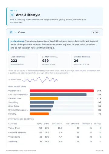
Crime & Safety
Police-recorded crime by category, with the trend.+6 checksShow detailsHide detailsPublished police.uk crime categories and monthly history in England and Wales, with missing months explained: the last six months and the 24-month total within a mile, every category's share and per-month rate, and the change between the last six months and the six before
- Last six months within a mile
- The 24-month total
- Every category's share
- Per-month rate by category
- Change against the six months before
- Missing months explained
Prints in: Area & lifestyle
Schools & Healthcare
Schools nearby, plus GPs, pharmacies and health context.+5 checksShow detailsHide detailsSchools with available inspection information, OpenStreetMap amenities such as GPs and pharmacies, and census health context: every school within 4 km with phase, grade and distance, and the nearest GP, pharmacy and health services by name
- Every school within 4 km
- Phase, grade and distance
- Nearest GP by name
- Nearest pharmacy and health services
- Census health context
Prints in: Area & lifestyle
Local Transport
Stations and stops nearby, with distances.+3 checksShow detailsHide detailsNearby rail stations and public transport stops with distances, where the source has records: stations with mode and lines, every stop within 800 m by type, and the nearest bus stop
- Stations with mode and lines
- Every stop within 800 m by type
- The nearest bus stop
Prints in: Area & lifestyle
Demographics
Who lives here, and how the area ranks on deprivation.+6 checksShow detailsHide detailsNeighbourhood deprivation and available census data, with different sources for each nation: the decile and rank of the small area with domains where published, residents and households, every census category with count and share including household tenure, and the statistical type of area with its pen portraits
- Deprivation decile and rank
- Domains where published
- Residents and households
- Every census category with count and share
- Household tenure
- Type of area with its pen portraits
Prints in: Area & lifestyle
Planning & Heritage
Designations, listed buildings and what shapes change nearby.+10 checksShow detailsHide detailsPublished planning designations, conservation areas, listed buildings and major projects; local publication varies. Included: every listed building and conservation area within 700 m with grade and distance, green belt, National Landscape, national park, scheduled monuments, tree preservation orders, Article 4 directions, the local plan's status and every brownfield-register entry nearby
- Listed buildings within 700 m
- Conservation areas within 700 m
- Green belt
- National Landscape and national park
- Scheduled monuments
- Tree preservation orders
- Article 4 directions
- The local plan's status
- Brownfield-register entries nearby
- Major projects
Prints in: The home & energy
Lifestyle & Amenities
Walkability, everyday amenities and food hygiene ratings.+4 checksShow detailsHide detailsNearby mapped amenities, walkability context and food hygiene ratings where records are available: a walkability score out of 100, every everyday category counted with its nearest distance, and every rated food business within about a mile with type, rating and inspection date
- Walkability score out of 100
- Every everyday category counted
- Nearest distance for each category
- Rated food businesses within about a mile
Prints in: Area & lifestyle
Rental & Market Context
Indicative rental yield and local price trends.+4 checksShow detailsHide detailsIndicative gross rental yield from area rents and price data, plus local house-price trends where available: the yield, the typical monthly rent and the value it was measured against, labelled as an area estimate
- Indicative gross rental yield
- Typical monthly rent
- The value it was measured against
- Local house-price trends
Prints in: Value & market
Contaminated Land & Permits
Former landfill, permits, discharges and incidents nearby.+6 checksShow detailsHide detailsEvery former landfill within 1 km measured to its boundary with its years in use, every permitted landfill within 2 km, substantiated pollution incidents, and all permits and discharges within 1 km de-duplicated by site, with the statutory register named as not read and how to get it
- Former landfill within 1 km, to its boundary
- Years each landfill was in use
- Permitted landfill within 2 km
- Substantiated pollution incidents
- Permits and discharges within 1 km
- The statutory register and how to get it
Prints in: Safety & environment
Council Tax & Tenure
What every band costs, the neighbours' bands and tenure.+7 checksShow detailsHide detailsThe Band D charge for the local authority this year, what every band costs per year and per month, the band mix of the neighbours, the tenure at the last recorded sale and across the street, published tribunal decisions at the postcode, and the lease-pack checklist
- Band D charge this year
- Every band per year and per month
- The neighbours' band mix
- Tenure at the last recorded sale
- Tenure across the street
- Tribunal decisions at the postcode
- The lease-pack checklist
Prints in: Value & market
Findings for This Address
Written for this address from registers that software cannot read.+4 checksShow detailsHide detailsA section written for this address from the registers that publish to people but not to software (each finding names the register consulted, where and when), plus dated corporate ownership and building records with their match basis
- Findings from registers with no software feed
- The register, place and date for each finding
- Dated corporate ownership records
- Building records with their match basis
Prints in: Written for the address
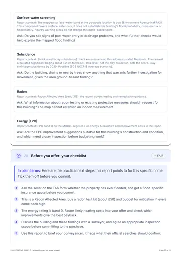
Verdict, Surveyor Questions & Checklist
The IQ Score, every flag explained, and your next steps.+5 checksShow detailsHide detailsThe IQ Score with every factor's sub-score and the finding behind it, every red and amber flag explained, a numbered brief of questions for your surveyor built from what the address flagged, your before-you-offer checklist, and an appendix of every register asked and whether it answered
- IQ Score with every factor's sub-score
- Every red and amber flag explained
- A numbered brief for your surveyor
- Your before-you-offer checklist
- Every register asked, and whether it answered
Prints in: The verdict
Pages from the sample report
Open the full sample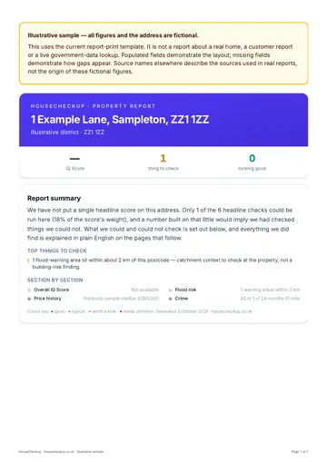 Report summary
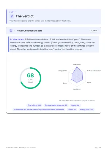 IQ Score and radar
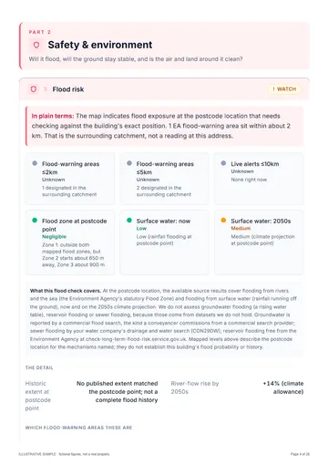 Flood risk
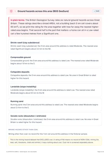 Ground hazards
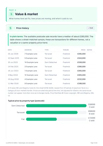 Price history
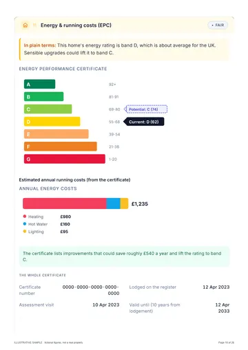 Energy (EPC)
 Crime
 Questions for your surveyor
Illustrative sample · fictional address
How HouseCheckup works
From search to full report in three simple steps.
- England, Wales & Scotland
Search any address
Enter an address in England, Wales and Scotland. Coverage varies by nation and source.
- Before you pay
See the IQ Score
See an initial area risk screen where enough data is available, with the checks and coverage behind the score.
- Emailed within 24 hours
Get the full report
Choose Lite (£9.99) or Complete (£24.99). The report is emailed to you within 24 hours, usually faster, with every source named and any check it could not run stated.
Still have a question? We typically respond within 24 hours.
Ready to check a property?
Enter the address you are thinking of buying. See the available area risk data, then choose an emailed report for the property.
Type the full address with its postcode to go straight to your report options. Try .
Reports from £9.99, one-off. Compare Lite and Complete
Cancel for a full refund at any time before your report is emailed. Terms
At a glance
One-off
No subscription
Pay once for each report you buy.
Named
Sources & coverage
Every report names its sources and the checks it could not run.
GB
England, Wales & Scotland
Coverage varies by nation and source, and is stated.
£9.99
Reports from
Lite £9.99, Complete £24.99.