Subsidence map of Great Britain: where the shrink-swell clay is
Last updated:
The British Geological Survey rates 392 of 4,233 five-kilometre cells in Great Britain Significant for shrink-swell clay and 945 Moderate. They cluster in the London Clay basin, the Essex and Kent estuaries, the Oxford–Bedford clay vale and the Hampshire basin. These are area ratings on a 65 km² grid, so check the exact postcode below.
Check a postcode against the grid
The map below is the national picture. For one postcode's cell — the six BGS ratings, how far away the nearest higher-rated cell begins, the coal-mining area status and recorded landslides — use the checker. It runs the same data this map is drawn from.
Shrink-swell clay across Great Britain, cell by cell
Every hexagon is one BGS GeoSure cell of about 65 km², coloured by its shrink-swell rating. Shrink-swell is clay that swells when wet and shrinks in dry summers, moving the ground under shallow foundations — the commonest cause of subsidence claims in Britain. Dark cells are rated Significant, amber Moderate, grey Low. Cells with no rating are off the grid (the sea, and Northern Ireland, which BGS does not map).
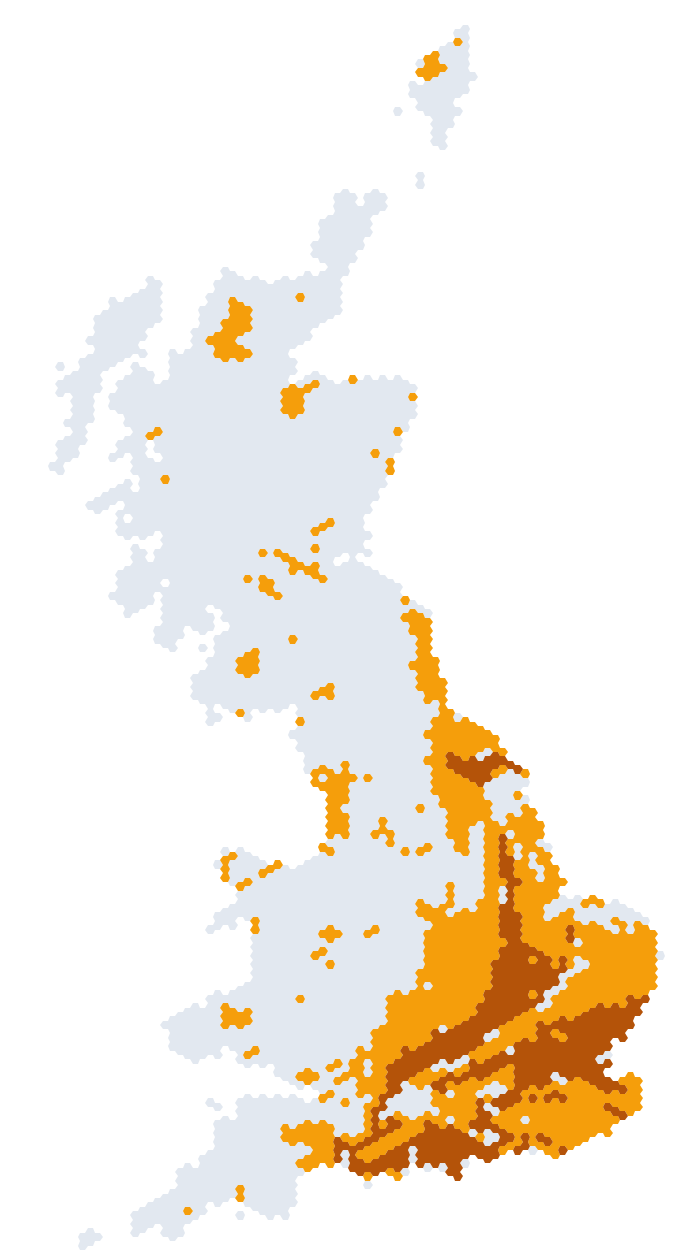
BGS notice: "Not suitable for local or site specific analysis, data is generalised for national overview uses only" Contains British Geological Survey materials © UKRI 2026. Contains Ordnance Survey data © Crown copyright and database right 2026. Open Government Licence v3.0.
All six ground hazards, counted
GeoSure rates six hazards on the same grid. Shrink-swell gets the attention because it drives most claims, but the others matter in their own regions: landslides on steep valley sides and soft cliffs, soluble rocks where chalk, limestone or gypsum can dissolve into hollows and sinkholes, compressible ground on peat and soft estuary deposits, running sand where water-saturated sand can flow into excavations, and collapsible deposits in a few wind-blown silt areas.
| Hazard | Significant | Moderate | Low | Share Moderate+ |
|---|---|---|---|---|
| Shrink–swell (clay subsidence) | 392 | 945 | 2,896 | 31.6% |
| Landslide (slope instability) | 692 | 1,510 | 2,026 | 52.1% |
| Soluble rocks (dissolution / sinkholes) | 282 | 176 | 3,837 | 10.7% |
| Compressible ground | 528 | 1 | 3,704 | 12.5% |
| Running sand | 170 | 189 | 3,874 | 8.5% |
| Collapsible deposits | 21 | 22 | 4,190 | 1% |
Cells rated on each layer out of 4,295 on the grid. Counts are read from the BGS GeoPackage (Version 8, ingested 2026-08-01) and checked against the totals recorded at ingest. Not suitable for local or site specific analysis, data is generalised for national overview uses only.
Where the worst-rated shrink-swell cells are, by region
Counted by Ordnance Survey 100 km map square — a fixed, published grid, so the regions are the same every time BGS refreshes the data. Each square is 10,000 km²; the label describes the sheet, not any one place in it.
| OS square | Covers | Significant | Moderate | Cells on grid |
|---|---|---|---|---|
| TL | Hertfordshire, Cambridgeshire, Bedfordshire and north Essex | 81 | 59 | 150 |
| SU | Hampshire, Berkshire, Oxfordshire, Wiltshire and West Sussex | 64 | 54 | 150 |
| TQ | London, Surrey, Kent and south Essex | 63 | 79 | 147 |
| SP | Northamptonshire, Warwickshire, Oxfordshire and Buckinghamshire | 35 | 98 | 149 |
| TF | Norfolk, the Fens and south Lincolnshire | 26 | 73 | 123 |
| TM | Suffolk and the Essex coast | 25 | 47 | 75 |
| SZ | Isle of Wight and the Solent coast | 23 | 0 | 29 |
| ST | Somerset, Bristol, Bath and the south Wales coast | 22 | 66 | 157 |
| SE | Yorkshire | 17 | 62 | 149 |
| SY | Dorset and south Somerset | 17 | 17 | 40 |
| TR | east Kent | 12 | 24 | 41 |
| TA | East Yorkshire coast and the Humber | 5 | 23 | 49 |
| TV | Beachy Head | 2 | 3 | 8 |
| SK | Nottinghamshire, Derbyshire, Leicestershire and Lincolnshire | 0 | 68 | 150 |
The clay belts, explained
The pattern on the map follows the geology, not the housing. Britain's clay-rich bedrock runs in bands from the south-west to the north-east, and the shrink-swell ratings trace those bands almost exactly.
London Clay underlies most of the London Basin — the capital north and south of the Thames, out through Essex and the north Kent coast. It is a stiff, highly plastic clay that swells in wet winters and shrinks in dry summers, which is why London and the Home Counties produce more subsidence claims than anywhere else and why so many of the Significant cells on the map are in the TQ and TL squares.
Gault Clay and Weald Clay form a second belt south of the chalk: the Gault runs beneath the foot of the Chilterns and the North Downs from the Vale of the White Horse to Kent, and the Weald Clay fills the low ground between the North and South Downs through Surrey, Sussex and Kent.
The Oxford, Ampthill and Kimmeridge Clays make up the Jurassic clay vale that runs from Dorset through Oxfordshire, Buckinghamshire and Bedfordshire to Peterborough and the Fens — the band of Moderate and Significant cells that crosses the SP, SU and TL squares diagonally.
Lias clays and the Mercia Mudstone run through Somerset, the Severn vale, Warwickshire and the East Midlands. They are generally less plastic than the London and Gault Clays, which is why much of the Midlands is rated Moderate rather than Significant.
Glacial till — the boulder clay left by the ice sheets — covers East Anglia, Lincolnshire and much of the north and gives those areas their own, more patchy, shrink-swell ratings. North of the glacial limit, and across most of Wales and Scotland, the bedrock is older and harder and shrink-swell is rated Low; there, the hazards that matter are landslides, soluble rocks and, in the coalfields, mining.
Two cautions. First, a rating describes a 65 km² cell: a road can run from a Low cell into a Significant one with no change in the ground beneath it, which is why every reading on this site carries the distance to the nearest higher-rated cell. Second, clay only moves foundations when something changes the water in it — a drought, a leaking drain, a thirsty tree too close to the wall — so the plot matters more than the map. Use the map to know which questions to ask; use a survey to answer them.
Sinkholes: the soluble-rocks map
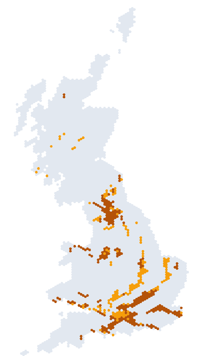
Sinkholes form where water dissolves the rock below — chalk under the Chilterns, the North Downs and Hampshire, limestone in the Peak District, the Mendips and the Yorkshire Dales, and gypsum around Ripon. BGS rates 282 cells Significant and 176 Moderate for soluble rocks. Worked example from the paid report: Ripon sits in a Low-rated cell with a Significant cell beginning about half a kilometre away, which is why a bare rating is never printed without the distance.
What the Complete report adds on ground stability for this address
Get the ground-stability findings — £24.99One-off · no subscription · Human-checked and emailed to you · see an illustrative sample
- The ground & subsidence panel for the address — coal mining, shrink–swell clay, recorded landslides and radon as traffic lights, with the six BGS GeoSure hazards rated for the grid cell and the distance to the nearest higher-rated cell
- The IQ Score, where subsidence, coal and radon together carry 46 of its 100 points, with the per-factor breakdown behind it
- What stands out at this address — the red and amber flags pulled together and explained
- The questions to put to your surveyor, written from what this address flagged — movement, mining and radon questions where they apply
Area ratings describe a grid cell, not the condition of one building, and do not replace a structural survey or a Coal Mining Risk Assessment.
100 areas on the map, with their cell reading
Every area page in the subsidence index, with its BGS shrink-swell cell rating. 84 sit in Significant cells and 8 in Moderate ones; the rest carry a different ground signal — an elevated clay class for the 2030s, recorded landslides, a coalfield or an elevated radon band. Each page prints the full six-hazard reading with the distance to the nearest higher-rated cell, the clay class for the 2030s and 2070s, coalfield status, recorded landslides and the radon band for that area.
| Area | Shrink-swell cell | Other hazards rated Moderate+ | Clay class (2030s) |
|---|---|---|---|
| OX2Oxford (north & west) | SignificantShrink–swell (clay subsidence): Significant across this 65 km² area (BGS GeoSure 5 km cell); no cell in Great Britain is rated higher for this hazard. | Compressible ground (Significant); Landslide (slope instability) (Significant); Running sand (Moderate) | Possible |
| SS1Southend-on-Sea | SignificantShrink–swell (clay subsidence): Significant across this 65 km² area (BGS GeoSure 5 km cell); no cell in Great Britain is rated higher for this hazard. | Collapsible deposits (Significant); Compressible ground (Significant); Running sand (Significant) | Probable |
| SS7Benfleet & Hadleigh | SignificantShrink–swell (clay subsidence): Significant across this 65 km² area (BGS GeoSure 5 km cell); no cell in Great Britain is rated higher for this hazard. | Compressible ground (Significant); Landslide (slope instability) (Significant); Running sand (Significant) | Probable |
| BR5Orpington | SignificantShrink–swell (clay subsidence): Significant across this 65 km² area (BGS GeoSure 5 km cell); no cell in Great Britain is rated higher for this hazard. | Running sand (Moderate); Soluble rocks (dissolution / sinkholes) (Significant); non-coal mining (Significant) | Possible |
| E12Manor Park, London | SignificantShrink–swell (clay subsidence): Significant across this 65 km² area (BGS GeoSure 5 km cell); no cell in Great Britain is rated higher for this hazard. | Compressible ground (Significant); Running sand (Moderate) | Probable |
| E14Canary Wharf, London | SignificantShrink–swell (clay subsidence): Significant across this 65 km² area (BGS GeoSure 5 km cell); no cell in Great Britain is rated higher for this hazard. | Compressible ground (Significant); Running sand (Moderate) | Probable |
| E16Royal Docks, London | SignificantShrink–swell (clay subsidence): Significant across this 65 km² area (BGS GeoSure 5 km cell); no cell in Great Britain is rated higher for this hazard. | Compressible ground (Significant); Running sand (Moderate) | Probable |
| BR1Bromley | SignificantShrink–swell (clay subsidence): Significant across this 65 km² area (BGS GeoSure 5 km cell); no cell in Great Britain is rated higher for this hazard. | Landslide (slope instability) (Moderate); non-coal mining (Significant) | Possible |
| CB6Ely & Littleport | SignificantShrink–swell (clay subsidence): Significant across this 65 km² area (BGS GeoSure 5 km cell); no cell in Great Britain is rated higher for this hazard. | Compressible ground (Significant) | Possible |
| CB7Ely | SignificantShrink–swell (clay subsidence): Significant across this 65 km² area (BGS GeoSure 5 km cell); no cell in Great Britain is rated higher for this hazard. | Compressible ground (Significant) | Probable |
| CO1Colchester | SignificantShrink–swell (clay subsidence): Significant across this 65 km² area (BGS GeoSure 5 km cell); no cell in Great Britain is rated higher for this hazard. | Collapsible deposits (Moderate) | Probable |
| CO2Colchester (south) | SignificantShrink–swell (clay subsidence): Significant across this 65 km² area (BGS GeoSure 5 km cell); no cell in Great Britain is rated higher for this hazard. | Collapsible deposits (Moderate) | Possible |
| CO4Colchester (north) | SignificantShrink–swell (clay subsidence): Significant across this 65 km² area (BGS GeoSure 5 km cell); no cell in Great Britain is rated higher for this hazard. | Collapsible deposits (Moderate) | Possible |
| DA15Sidcup | SignificantShrink–swell (clay subsidence): Significant across this 65 km² area (BGS GeoSure 5 km cell); no cell in Great Britain is rated higher for this hazard. | Landslide (slope instability) (Moderate); non-coal mining (Moderate) | Probable |
| MK11Stony Stratford, Milton Keynes | SignificantShrink–swell (clay subsidence): Significant across this 65 km² area (BGS GeoSure 5 km cell); no cell in Great Britain is rated higher for this hazard. | Soluble rocks (dissolution / sinkholes) (Moderate) | Possible |
| PE1Peterborough | SignificantShrink–swell (clay subsidence): Significant across this 65 km² area (BGS GeoSure 5 km cell); no cell in Great Britain is rated higher for this hazard. | Soluble rocks (dissolution / sinkholes) (Moderate) | Possible |
| PE7Peterborough (south) | SignificantShrink–swell (clay subsidence): Significant across this 65 km² area (BGS GeoSure 5 km cell); no cell in Great Britain is rated higher for this hazard. | Compressible ground (Significant) | Possible |
| RM12Hornchurch | SignificantShrink–swell (clay subsidence): Significant across this 65 km² area (BGS GeoSure 5 km cell); no cell in Great Britain is rated higher for this hazard. | Compressible ground (Significant) | Probable |
| SE13Lewisham, London | SignificantShrink–swell (clay subsidence): Significant across this 65 km² area (BGS GeoSure 5 km cell); no cell in Great Britain is rated higher for this hazard. | Landslide (slope instability) (Moderate); non-coal mining (Significant) | Probable |
| SE18Woolwich, London | SignificantShrink–swell (clay subsidence): Significant across this 65 km² area (BGS GeoSure 5 km cell); no cell in Great Britain is rated higher for this hazard. | Landslide (slope instability) (Moderate); non-coal mining (Moderate) | Probable |
| SE23Forest Hill, London | SignificantShrink–swell (clay subsidence): Significant across this 65 km² area (BGS GeoSure 5 km cell); no cell in Great Britain is rated higher for this hazard. | Landslide (slope instability) (Moderate) | Probable |
| SS0Westcliff & Southend | SignificantShrink–swell (clay subsidence): Significant across this 65 km² area (BGS GeoSure 5 km cell); no cell in Great Britain is rated higher for this hazard. | Collapsible deposits (Significant) | Probable |
| SS6Rayleigh | SignificantShrink–swell (clay subsidence): Significant across this 65 km² area (BGS GeoSure 5 km cell); no cell in Great Britain is rated higher for this hazard. | Collapsible deposits (Significant) | Probable |
| CB3Cambridge (west) | SignificantShrink–swell (clay subsidence): Significant across this 65 km² area (BGS GeoSure 5 km cell); no cell in Great Britain is rated higher for this hazard. | — | Possible |
| CB4Cambridge (north) | SignificantShrink–swell (clay subsidence): Significant across this 65 km² area (BGS GeoSure 5 km cell); no cell in Great Britain is rated higher for this hazard. | — | Possible |
| CM1Chelmsford | SignificantShrink–swell (clay subsidence): Significant across this 65 km² area (BGS GeoSure 5 km cell); no cell in Great Britain is rated higher for this hazard. | — | Probable |
| CM12Billericay | SignificantShrink–swell (clay subsidence): Significant across this 65 km² area (BGS GeoSure 5 km cell); no cell in Great Britain is rated higher for this hazard. | — | Possible |
| CM13Hutton, Brentwood | SignificantShrink–swell (clay subsidence): Significant across this 65 km² area (BGS GeoSure 5 km cell); no cell in Great Britain is rated higher for this hazard. | — | Possible |
| CM14Brentwood | SignificantShrink–swell (clay subsidence): Significant across this 65 km² area (BGS GeoSure 5 km cell); no cell in Great Britain is rated higher for this hazard. | — | Possible |
| CM2Chelmsford (south) | SignificantShrink–swell (clay subsidence): Significant across this 65 km² area (BGS GeoSure 5 km cell); no cell in Great Britain is rated higher for this hazard. | — | Possible |
| CM3Chelmsford (rural east) | SignificantShrink–swell (clay subsidence): Significant across this 65 km² area (BGS GeoSure 5 km cell); no cell in Great Britain is rated higher for this hazard. | — | Possible |
| CR0Croydon | SignificantShrink–swell (clay subsidence): Significant across this 65 km² area (BGS GeoSure 5 km cell); no cell in Great Britain is rated higher for this hazard. | —non-coal mining (Moderate) | Probable |
| E1Whitechapel & Shoreditch, London | SignificantShrink–swell (clay subsidence): Significant across this 65 km² area (BGS GeoSure 5 km cell); no cell in Great Britain is rated higher for this hazard. | — | Probable |
| E17Walthamstow, London | SignificantShrink–swell (clay subsidence): Significant across this 65 km² area (BGS GeoSure 5 km cell); no cell in Great Britain is rated higher for this hazard. | — | Probable |
| EN2Enfield (north) | SignificantShrink–swell (clay subsidence): Significant across this 65 km² area (BGS GeoSure 5 km cell); no cell in Great Britain is rated higher for this hazard. | — | Probable |
| EN6Potters Bar | SignificantShrink–swell (clay subsidence): Significant across this 65 km² area (BGS GeoSure 5 km cell); no cell in Great Britain is rated higher for this hazard. | —non-coal mining (Moderate) | Possible |
| HA1Harrow | SignificantShrink–swell (clay subsidence): Significant across this 65 km² area (BGS GeoSure 5 km cell); no cell in Great Britain is rated higher for this hazard. | —non-coal mining (Moderate) | Probable |
| HA2Harrow (south) | SignificantShrink–swell (clay subsidence): Significant across this 65 km² area (BGS GeoSure 5 km cell); no cell in Great Britain is rated higher for this hazard. | —non-coal mining (Moderate) | Probable |
| HA5Pinner | SignificantShrink–swell (clay subsidence): Significant across this 65 km² area (BGS GeoSure 5 km cell); no cell in Great Britain is rated higher for this hazard. | —non-coal mining (Significant) | Probable |
| IG1Ilford | SignificantShrink–swell (clay subsidence): Significant across this 65 km² area (BGS GeoSure 5 km cell); no cell in Great Britain is rated higher for this hazard. | — | Probable |
| IG11Barking | SignificantShrink–swell (clay subsidence): Significant across this 65 km² area (BGS GeoSure 5 km cell); no cell in Great Britain is rated higher for this hazard. | — | Probable |
| KT1Kingston upon Thames | SignificantShrink–swell (clay subsidence): Significant across this 65 km² area (BGS GeoSure 5 km cell); no cell in Great Britain is rated higher for this hazard. | — | Probable |
| KT17Epsom & Ewell | SignificantShrink–swell (clay subsidence): Significant across this 65 km² area (BGS GeoSure 5 km cell); no cell in Great Britain is rated higher for this hazard. | —non-coal mining (Significant) | Probable |
| KT2Kingston & Coombe | SignificantShrink–swell (clay subsidence): Significant across this 65 km² area (BGS GeoSure 5 km cell); no cell in Great Britain is rated higher for this hazard. | — | Probable |
| KT8East Molesey & Hampton Court | SignificantShrink–swell (clay subsidence): Significant across this 65 km² area (BGS GeoSure 5 km cell); no cell in Great Britain is rated higher for this hazard. | — | Probable |
| KT9Chessington | SignificantShrink–swell (clay subsidence): Significant across this 65 km² area (BGS GeoSure 5 km cell); no cell in Great Britain is rated higher for this hazard. | — | Probable |
| MK10Milton Keynes (east) | SignificantShrink–swell (clay subsidence): Significant across this 65 km² area (BGS GeoSure 5 km cell); no cell in Great Britain is rated higher for this hazard. | — | Probable |
| MK40Bedford | SignificantShrink–swell (clay subsidence): Significant across this 65 km² area (BGS GeoSure 5 km cell); no cell in Great Britain is rated higher for this hazard. | — | Probable |
| MK41Bedford (north) | SignificantShrink–swell (clay subsidence): Significant across this 65 km² area (BGS GeoSure 5 km cell); no cell in Great Britain is rated higher for this hazard. | — | Possible |
| MK42Bedford (south) | SignificantShrink–swell (clay subsidence): Significant across this 65 km² area (BGS GeoSure 5 km cell); no cell in Great Britain is rated higher for this hazard. | — | Probable |
| N10Muswell Hill, London | SignificantShrink–swell (clay subsidence): Significant across this 65 km² area (BGS GeoSure 5 km cell); no cell in Great Britain is rated higher for this hazard. | — | Probable |
| N13Palmers Green, London | SignificantShrink–swell (clay subsidence): Significant across this 65 km² area (BGS GeoSure 5 km cell); no cell in Great Britain is rated higher for this hazard. | — | Probable |
| N20Whetstone & Totteridge, London | SignificantShrink–swell (clay subsidence): Significant across this 65 km² area (BGS GeoSure 5 km cell); no cell in Great Britain is rated higher for this hazard. | — | Probable |
| N22Enfield | SignificantShrink–swell (clay subsidence): Significant across this 65 km² area (BGS GeoSure 5 km cell); no cell in Great Britain is rated higher for this hazard. | — | Probable |
| N4Finsbury Park, London | SignificantShrink–swell (clay subsidence): Significant across this 65 km² area (BGS GeoSure 5 km cell); no cell in Great Britain is rated higher for this hazard. | — | Probable |
| NW1Camden, London | SignificantShrink–swell (clay subsidence): Significant across this 65 km² area (BGS GeoSure 5 km cell); no cell in Great Britain is rated higher for this hazard. | — | Probable |
| NW6Kilburn & West Hampstead, London | SignificantShrink–swell (clay subsidence): Significant across this 65 km² area (BGS GeoSure 5 km cell); no cell in Great Britain is rated higher for this hazard. | — | Probable |
| NW9Kingsbury & Colindale, London | SignificantShrink–swell (clay subsidence): Significant across this 65 km² area (BGS GeoSure 5 km cell); no cell in Great Britain is rated higher for this hazard. | — | Probable |
| OX14Abingdon | SignificantShrink–swell (clay subsidence): Significant across this 65 km² area (BGS GeoSure 5 km cell); no cell in Great Britain is rated higher for this hazard. | — | Possible |
| OX33Wheatley, Oxfordshire | SignificantShrink–swell (clay subsidence): Significant across this 65 km² area (BGS GeoSure 5 km cell); no cell in Great Britain is rated higher for this hazard. | — | Possible |
| OX4Oxford | SignificantShrink–swell (clay subsidence): Significant across this 65 km² area (BGS GeoSure 5 km cell); no cell in Great Britain is rated higher for this hazard. | — | Probable |
| RM1Romford | SignificantShrink–swell (clay subsidence): Significant across this 65 km² area (BGS GeoSure 5 km cell); no cell in Great Britain is rated higher for this hazard. | — | Probable |
| RM6Chadwell Heath | SignificantShrink–swell (clay subsidence): Significant across this 65 km² area (BGS GeoSure 5 km cell); no cell in Great Britain is rated higher for this hazard. | — | Probable |
| SE1Southwark, London | SignificantShrink–swell (clay subsidence): Significant across this 65 km² area (BGS GeoSure 5 km cell); no cell in Great Britain is rated higher for this hazard. | — | Probable |
| SE15Peckham, London | SignificantShrink–swell (clay subsidence): Significant across this 65 km² area (BGS GeoSure 5 km cell); no cell in Great Britain is rated higher for this hazard. | —non-coal mining (Moderate) | Probable |
| SE26Bromley | SignificantShrink–swell (clay subsidence): Significant across this 65 km² area (BGS GeoSure 5 km cell); no cell in Great Britain is rated higher for this hazard. | — | Probable |
| SE5Lambeth | SignificantShrink–swell (clay subsidence): Significant across this 65 km² area (BGS GeoSure 5 km cell); no cell in Great Britain is rated higher for this hazard. | —non-coal mining (Moderate) | Probable |
| SE8Greenwich | SignificantShrink–swell (clay subsidence): Significant across this 65 km² area (BGS GeoSure 5 km cell); no cell in Great Britain is rated higher for this hazard. | — | Probable |
| SL1Slough | SignificantShrink–swell (clay subsidence): Significant across this 65 km² area (BGS GeoSure 5 km cell); no cell in Great Britain is rated higher for this hazard. | —non-coal mining (Moderate) | Possible |
| SM1Sutton | SignificantShrink–swell (clay subsidence): Significant across this 65 km² area (BGS GeoSure 5 km cell); no cell in Great Britain is rated higher for this hazard. | —non-coal mining (Moderate) | Probable |
| SW11Battersea, London | SignificantShrink–swell (clay subsidence): Significant across this 65 km² area (BGS GeoSure 5 km cell); no cell in Great Britain is rated higher for this hazard. | — | Probable |
| SW16Streatham, London | SignificantShrink–swell (clay subsidence): Significant across this 65 km² area (BGS GeoSure 5 km cell); no cell in Great Britain is rated higher for this hazard. | — | Probable |
| SW18Wandsworth, London | SignificantShrink–swell (clay subsidence): Significant across this 65 km² area (BGS GeoSure 5 km cell); no cell in Great Britain is rated higher for this hazard. | — | Probable |
| SW1AWestminster, London | SignificantShrink–swell (clay subsidence): Significant across this 65 km² area (BGS GeoSure 5 km cell); no cell in Great Britain is rated higher for this hazard. | — | Probable |
| SW20Raynes Park, London | SignificantShrink–swell (clay subsidence): Significant across this 65 km² area (BGS GeoSure 5 km cell); no cell in Great Britain is rated higher for this hazard. | — | Probable |
| SW3Chelsea, London | SignificantShrink–swell (clay subsidence): Significant across this 65 km² area (BGS GeoSure 5 km cell); no cell in Great Britain is rated higher for this hazard. | — | Probable |
| TW1Twickenham | SignificantShrink–swell (clay subsidence): Significant across this 65 km² area (BGS GeoSure 5 km cell); no cell in Great Britain is rated higher for this hazard. | — | Probable |
| TW3Hounslow | SignificantShrink–swell (clay subsidence): Significant across this 65 km² area (BGS GeoSure 5 km cell); no cell in Great Britain is rated higher for this hazard. | — | Possible |
| W11Notting Hill, London | SignificantShrink–swell (clay subsidence): Significant across this 65 km² area (BGS GeoSure 5 km cell); no cell in Great Britain is rated higher for this hazard. | — | Probable |
| W2Paddington & Bayswater, London | SignificantShrink–swell (clay subsidence): Significant across this 65 km² area (BGS GeoSure 5 km cell); no cell in Great Britain is rated higher for this hazard. | — | Probable |
| W3Acton, London | SignificantShrink–swell (clay subsidence): Significant across this 65 km² area (BGS GeoSure 5 km cell); no cell in Great Britain is rated higher for this hazard. | — | Probable |
| W4Chiswick, London | SignificantShrink–swell (clay subsidence): Significant across this 65 km² area (BGS GeoSure 5 km cell); no cell in Great Britain is rated higher for this hazard. | — | Probable |
| WD19South Oxhey, Watford | SignificantShrink–swell (clay subsidence): Significant across this 65 km² area (BGS GeoSure 5 km cell); no cell in Great Britain is rated higher for this hazard. | —non-coal mining (Moderate) | Possible |
| WD6Borehamwood | SignificantShrink–swell (clay subsidence): Significant across this 65 km² area (BGS GeoSure 5 km cell); no cell in Great Britain is rated higher for this hazard. | — | Possible |
| BA1Bath | ModerateShrink–swell (clay subsidence): Moderate across this 65 km² area (BGS GeoSure 5 km cell); the nearest Significant-rated cell begins about 10.2 km E. | Landslide (slope instability) (Significant) | Improbable |
| BA2Bath (south & west) | ModerateShrink–swell (clay subsidence): Moderate across this 65 km² area (BGS GeoSure 5 km cell); the nearest Significant-rated cell begins about 9 km SE. | Landslide (slope instability) (Significant); non-coal mining (Significant) | Improbable |
| BS8Clifton, Bristol | ModerateShrink–swell (clay subsidence): Moderate across this 65 km² area (BGS GeoSure 5 km cell); the nearest Significant-rated cell begins about 28.1 km E. | Landslide (slope instability) (Moderate); non-coal mining (Significant) | Improbable |
| UB1Southall | ModerateShrink–swell (clay subsidence): Moderate across this 65 km² area (BGS GeoSure 5 km cell); the nearest Significant-rated cell begins about 1.3 km SE. | Collapsible deposits (Moderate) | Probable |
| NE1Newcastle upon Tyne | ModerateShrink–swell (clay subsidence): Moderate across this 65 km² area (BGS GeoSure 5 km cell); the nearest Significant-rated cell begins about 70 km S. | — | Improbable |
| NE2Jesmond, Newcastle | ModerateShrink–swell (clay subsidence): Moderate across this 65 km² area (BGS GeoSure 5 km cell); the nearest Significant-rated cell begins about 71.5 km S. | — | Improbable |
| RG1Reading | ModerateShrink–swell (clay subsidence): Moderate across this 65 km² area (BGS GeoSure 5 km cell); the nearest Significant-rated cell begins about 0.2 km N. | —non-coal mining (Significant) | Possible |
| SL4Windsor | ModerateShrink–swell (clay subsidence): Moderate across this 65 km² area (BGS GeoSure 5 km cell); the nearest Significant-rated cell begins about 1.5 km N. | — | Probable |
| BL1Bolton | LowShrink–swell (clay subsidence): Low across this 65 km² area (BGS GeoSure 5 km cell); the nearest Moderate-rated cell begins about 2 km NE. | Landslide (slope instability) (Moderate) | Improbable |
| DH1Durham | LowShrink–swell (clay subsidence): Low across this 65 km² area (BGS GeoSure 5 km cell); the nearest Moderate-rated cell begins about 2.5 km N. | Landslide (slope instability) (Moderate) | Improbable |
| HD1Huddersfield | LowShrink–swell (clay subsidence): Low across this 65 km² area (BGS GeoSure 5 km cell); the nearest Moderate-rated cell begins about 14.4 km S. | Landslide (slope instability) (Significant) | Improbable |
| LS10Hunslet, Leeds | LowShrink–swell (clay subsidence): Low across this 65 km² area (BGS GeoSure 5 km cell); the nearest Moderate-rated cell begins about 11.4 km NW. | Landslide (slope instability) (Moderate) | Improbable |
| ST1Stoke-on-Trent | LowShrink–swell (clay subsidence): Low across this 65 km² area (BGS GeoSure 5 km cell); the nearest Moderate-rated cell begins about 25.5 km SW. | Landslide (slope instability) (Moderate) | Improbable |
| TQ1Torquay | LowShrink–swell (clay subsidence): Low across this 65 km² area (BGS GeoSure 5 km cell); the nearest Moderate-rated cell begins about 18.3 km N. | Landslide (slope instability) (Moderate) | Improbable |
| BH1Bournemouth | LowShrink–swell (clay subsidence): Low across this 65 km² area (BGS GeoSure 5 km cell); the nearest Significant-rated cell begins about 1.8 km NW. | — | Improbable |
| CB1Cambridge | LowShrink–swell (clay subsidence): Low across this 65 km² area (BGS GeoSure 5 km cell); the nearest Significant-rated cell begins about 2.4 km N. | — | Probable |
Cell readings are taken at each outcode's representative point (postcodes.io centroid) against the bundled BGS grid. "Clay class" is the separate BGS GeoClimate UKCP18 shrink-swell class for the 2030 average scenario. Not suitable for local or site specific analysis, data is generalised for national overview uses only.
Frequently asked questions
Is there a subsidence map for the UK?
Yes, for Great Britain. The British Geological Survey publishes GeoSure, which rates six natural ground hazards — including shrink-swell clay, the commonest cause of subsidence — on a 5 km hexagonal grid under the Open Government Licence. This page summarises that grid: 392 of 4,233 cells are rated Significant for shrink-swell and 945 Moderate. Northern Ireland is not covered; it has no GeoSure equivalent.
Which areas of the UK have the most subsidence-prone clay?
By count of Significant shrink-swell cells on the BGS grid, the map squares covering Hertfordshire, Cambridgeshire, Bedfordshire and north Essex (81 cells), Hampshire, Berkshire, Oxfordshire, Wiltshire and West Sussex (64) and London, Surrey, Kent and south Essex (63) lead. Geologically that is the London Clay of the London Basin, the Gault and Weald Clays south of it, and the Oxford–Kimmeridge clay vale running from Oxfordshire through Bedfordshire to Peterborough.
Is my house on clay?
The map can tell you whether the 5 km cell around a postcode is rated Low, Moderate or Significant for shrink-swell, and how far away the nearest higher-rated cell begins. It cannot tell you what is under one house: the cell covers about 65 km², and which side of a cell edge a home falls on is arbitrary. Enter the postcode in the checker above for the cell reading, then ask the surveyor about the soil, the trees and the drains at the plot.
Does a Significant rating mean the house will subside?
No. GeoSure classes are susceptibility ratings for an area, not probabilities of a claim at an address. Most homes in Significant cells never move. Whether a particular house does depends on its foundations, nearby trees, leaking drains, made ground and the weather — property-level factors only a survey assesses. Treat the rating as a reason to ask specific questions, not as a verdict.
What is the difference between this map and the postcode checker?
The map is the whole-country picture: counts of cells by class and by region, so you can see where the clay belts are. The checker gives one postcode's cell reading from the same grid — the six ratings and the distance to the nearest higher-rated cell — plus the coal-mining area status and recorded landslides for that area. Both are area-level. The Complete report runs the same panel for one address and adds the radon band and the questions for your surveyor.
Where does the data come from and can I use it myself?
From the British Geological Survey's GeoSure 5 km hex grid (Version 8), free for commercial, research and public use under the Open Government Licence, ingested 2026-08-01. BGS attaches a notice to every cell: "Not suitable for local or site specific analysis, data is generalised for national overview uses only". You can download the grid from the BGS dataset page linked in the sources below.
Go deeper
Sources
- GeoSure 5 km hex grid (Version 8) — British Geological Survey, ingested 2026-08-01
- GeoClimate UKCP18 shrink-swell — British Geological Survey (clay class on the area pages)
- Open Government Licence v3.0 — Free for commercial, research and public use under the Open Government Licence. Please acknowledge the material. (bgs.ac.uk dataset pages, read 2026-08-01.)
Contains British Geological Survey materials © UKRI 2026. Contains Ordnance Survey data © Crown copyright and database right 2026. Open Government Licence v3.0.