Find the home
Pick the full address, then choose your report.
Have a property listing? Paste its address or text
A Rightmove, Zoopla or OnTheMarket link can identify the portal, but a link alone cannot retrieve the address here. Paste the address or a short section of listing text. It is processed in your browser.
Check this house before you make an offer.
Flood, ground and radon risks, what nearby homes really sold for, energy and planning, from official records for this one address, emailed to you. If a check can't be run, we tell you.
Lite £9.99Complete £24.99England, Wales and Scotland · coverage varies by source · Human-checked and emailed to you
🔒 Secure checkout by Stripe · Human-checked and emailed to you within 24 hours, usually faster · one-off payment, no subscription.
What the report looks like inside
See the full sample →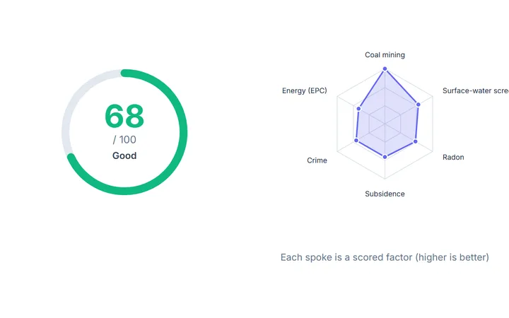 IQ Score and the factors behind it
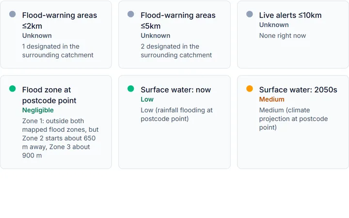 Flood risk at the postcode point
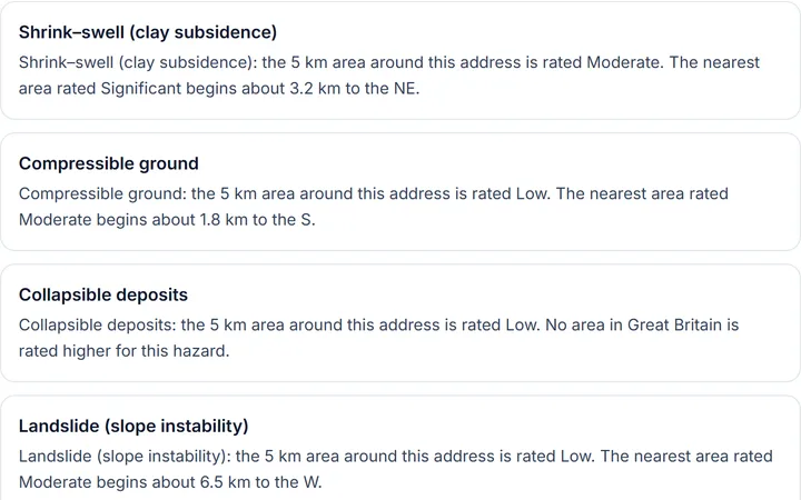 Six ground hazards, rated for the area
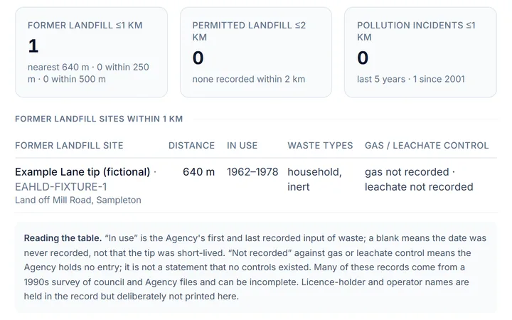 Landfill, permits and incidents nearby
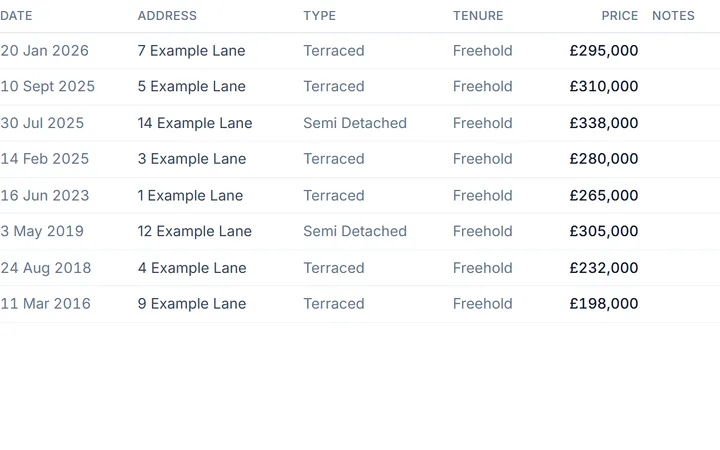 What homes here sold for
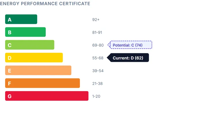 The energy rating, now and after upgrades
Illustrative sample · fictional address · cut from the sample report as it prints
What's in the report
Official-source property screening, emailed to you as a PDF. Coverage and missing checks are explained in the report. You choose Lite or Complete after confirming the address.
Complete is the full document: 33 sections, from the IQ Score and what stands out, through flood, ground, contaminated land and air quality, the full street sale history, council tax and tenure, the whole energy certificate, heritage and planning, crime, schools, transport, noise and who lives here, to a hand-checked section, the questions for your surveyor and your checklist. Lite is the hazard-screening part of the same document.
Full contents of the Complete report
Grouped under the report's own part headings. Sections print where your address has usable data; a check that could not be run is named in the report, not scored as a pass.
The verdict
The 6-factor IQ Score out of 100 with its band, the per-factor breakdown behind it, and the coverage gaps identified rather than scored as a pass
- The score out of 100 and its band on the cover, built from 6 weighted factors: flood, crime, coal mining, subsidence, radon and energy
- How we scored it: each factor's 0–100 sub-score as a bar, with the finding that produced it
- A factor that could not be checked is removed and the rest re-weighted; if too little could be answered, no headline score is published at all
The plain-English read on what stands out at this address: every red and amber flag pulled together and explained, with the top things to check on the cover
- Every red and amber flag from across the report in one list, each explained in plain English
- Top things to check on the cover, drawn from the same flags
Safety & environment
Flood risk and flood history from the official national maps for your nation, plus flood defences nearby: the mapped flood zone and surface-water risk now and in the 2050s, every flood-warning area within 2 km and 5 km named, recorded flood events, the climate allowances to plan for and whether a policy here could be backed by the Flood Re scheme
- Traffic-light cells for the mapped flood zone at the postcode point, surface-water flooding now and in the 2050s, flood-warning areas within 2 km and 5 km, and live alerts within 10 km
- Every flood-warning area behind those counts, named, where the national warning feed covers the address, so you can see which catchment the home sits in
- Whether the postcode point sits inside a recorded flood extent, with the recorded events, their dates, source and cause
- The river-flow climate allowances to plan for across three epochs at three percentiles, and whether a flood policy could be backed by the Flood Re scheme, with the reasons, the premium ceiling for the council-tax band and the mandatory caveats
- What the flood check does and does not cover: groundwater, sewer and reservoir flooding are named as outside it, with where to get each
- Scotland and Wales: that nation's own flood maps and recorded extents, with the address-level history gap stated rather than hidden
- Flood defences: every flood-management asset within about 1.5 km grouped by type (walls, embankments, culverts, outfalls, maintained channels and natural high ground), each with its watercourse, distance, graded condition, below-target flag, maintainer and last inspection, plus capital flood schemes within 5 km; 'checked and none' and 'did not answer' are printed as distinct states
- The question to put on the TA6 form and the insurance quote to get before you commit
Ground stability and subsidence screening, radon, and coal-mining area screening: clay shrink-swell for the 2030s and 2070s, every recorded landslide nearby, the radon band for the 1 km square, the coal-mining risk-area status, the ground level at the point, and the seven ground-hazard ratings for the surrounding area with the layer that drives the rating
- Traffic-light cells for coal mining, clay shrink-swell, recorded landslides and radon, with the layer that drives the overall ground rating named
- Clay shrink-swell class for the 2030s and 2070s under climate change, with the legend and the reason where a horizon could not be rated
- Every recorded landslide within the search radius, with name, locality, distance and known dates
- Radon band out of 6 for the 1 km square, whether it is an Affected Area, whether protective measures are likely for new build, what it means for this home and what a test kit costs
- The coal-mining screen: Development High or Low Risk Area status, high-risk-area proximity and the exact layer consulted. An incomplete screen is named as incomplete, never read as clear
- Ground level above sea level at the point and the tallest object within 15 m from the national laser height survey, with the sample's provenance
- The six natural ground hazards rated for the surrounding 5 km cell (shrink-swell clay, landslides, soluble rocks, compressible ground, collapsible deposits and running sand), plus the non-coal mining layer for the 1 km cell
- For each hazard, how far away the nearest higher-rated cell begins. That is the half that matters, because a Low cell can sit a few hundred metres from a Significant one
- An explicit refusal, never an empty table, where the national ground-hazard model does not reach
Contaminated-land screening: historic landfill footprints with distance to the property, authorised landfill sites, recorded pollution incidents and environmental permits nearby (England; named as not checked elsewhere). Every former landfill within 1 km measured to its boundary, every permitted landfill within 2 km, all permits and discharges within 1 km de-duplicated by site, and the statutory register named as not read with the route to get it
- Every former landfill site within 1 km measured to the edge of its footprint (whether it lies under the address, its years in use and what is recorded about gas and leachate control), with further sites out to the wider radius as context
- Every permitted landfill boundary within 2 km with status, permit reference and the date issued
- Substantiated pollution incidents within 1 km, recent and older, with the publisher's information warning and the snapshot dates
- Environmental permits and discharges within 1 km, de-duplicated by site (storm overflows, industrial installations, waste operations, water and groundwater discharges, radioactive-substance registrations), with the number of permits each site holds
- Every monitored storm overflow within 1 km with its spill count and total hours for each year of the annual return, flagged where the monitor ran under 90 % of the year, the watercourse it discharges to, and the spill record printed beside its permit where the references align
- The statutory contaminated-land register (Part 2A) named as held by the council and not read, with the CON29 route to obtain it
- Scotland: the regulated-sites registers for that nation in place of the England registers
Air quality, coastal erosion where mapped, and major infrastructure projects: modelled nitrogen dioxide, PM2.5 and PM10 at the address against the legal objectives, the shoreline plan and its policy for each epoch on a managed coast, and every nationally significant project within about 8 km with its stage
- Modelled annual-mean nitrogen dioxide, PM2.5 and PM10 at the address in µg/m³ against the legal objectives, with the worst pollutant named and what to ask if anyone in the household has a breathing condition
- Kerbside nitrogen dioxide on the nearest busy road, and the days a year modelled above the ozone threshold
- A failed lookup printed as a failed lookup, never as clean air
- Coastal erosion on a managed coastline: the shoreline management plan, the policy unit and the policy for each epoch, including how it changes under the high climate-change allowance
- Every nationally significant infrastructure project within about 8 km (power, transport and water schemes) with type, stage and distance
Value & market
Value and market: the full recorded sale history for the street with tenure and new-build flags, local price context by property type, gross rental yield, what every council tax band costs here, and the tenure at the last sale with any published tribunal decisions
- The full recorded sale history for the street (or postcode), newest first: every sale with date, address, property type, tenure, price and new-build flag, with non-market transactions explained; nothing cut to the first dozen
- Other sales in the postcode, the median sale price, typical price by property type, and how the wider area compares: local, regional and national average price by property type with sales volume and annual change
- Scotland: neighbourhood-level sale statistics with an official per-address route, because no open per-address sold price exists there
- Gross rental yield against the going local rent: the yield, the typical monthly rent and the price it was measured against, labelled as an area estimate
- Council tax: the Band D charge for the local authority this year, what every band costs per year and per month, which band is most common in this small area and the full band mix of the neighbours
- Tenure at the last recorded sale, the tenure pattern of every recorded sale on the street, occupancy declared on the energy certificate, every published property-tribunal decision at the postcode with case reference and link, and the lease-pack checklist of what to demand from the seller
The home & energy
The home and energy: property facts, the whole energy certificate (every element with its star rating, running costs now and after the costed improvements), solar potential, broadband and mobile, every listed building and conservation area within 700 m, and the planning and land designations that shape what you can change
- Property facts: local authority, ward, region, dwelling type, built form, construction age band, floor area in m² and sq ft, occupancy at the energy assessment and the property reference number
- The whole energy certificate: current and potential band and score, estimated running costs for heating, hot water and lighting now and after the recommended works, every element the assessor rated (walls, roof, floor, windows, heating, controls, hot water, lighting) with its energy and environmental star ratings, every recommended improvement with indicative cost, typical yearly saving and the rating after, rooms, glazing, draught-proofing, carbon footprint now and potential, certificate number and validity, and a verdict on how the home is built
- No certificate for the address, or a register that did not answer, printed as exactly that, never a neighbour's certificate in its place
- Solar potential: modelled output per kW installed and for a typical 4 kW system, with the best roof angle and direction
- Broadband & mobile: predicted fastest download speed, superfast, ultrafast and gigabit availability and indoor signal on all four networks where the postcode data answers; otherwise stated plainly as not checked, with the two-minute check to run yourself
- Heritage: whether the home sits inside a conservation area, every conservation area within 700 m with inside/outside and the distance to its boundary, and every listed building within 700 m with grade, distance and listing date; Scotland uses its own designation register and categories
- Planning & land designations: green belt, National Landscape (AONB), national park, scheduled monuments, World Heritage Site, air-quality management area, heritage coast, ancient woodland, tree preservation orders, Article 4 directions, built-up area, agricultural land class, heritage at risk within 250 m, registered parks and gardens, local nature reserves, the local plan's status and housing requirement, and every brownfield-register entry within the measured radius (current and since removed)
Area & lifestyle
Area and lifestyle: a plain-English picture of the area, walkability with every everyday amenity counted, crime by category over 24 months, every school within 4 km with its grade, stations and stops with distances, road noise, neighbourhood deprivation, the census profile of who lives here, and food hygiene ratings nearby
- About this area: a plain-English summary of the place and its surroundings
- Amenities & walkability: a walkability score out of 100, the count and nearest distance for every everyday category within about 2.5 km (shops, schools, health, parks, food) and the nearest schools and GP, pharmacy and health services by name and distance
- Crime: incidents within about a mile for the last six months and the full 24-month total, months tracked, the 24-month trend, a chart of every category and a table giving each category's total, share, per-month rate and the change between the last six months and the six before
- Schools: every school within 4 km with phase, inspection grade where one is published and distance; Scotland lists its schools with the inspectorate's narrative instead of a grade
- Getting around: rail and metro stations with distance, mode and lines, and every public-transport stop within 800 m by type, with the nearest bus stop
- Noise: the road-traffic noise band, the nearest busy road, every counted road nearby with vehicles and HGVs a day and HGV share, and whether the address sits in or near a mapped noise hotspot
- Neighbourhood deprivation: the decile and rank of this small area on the national index, with the domain breakdown where the nation publishes one
- Who lives here: residents, households and every category of each census table with count and share (including how households across the neighbourhood own, mortgage or rent), plus the statistical type of area with its pen portraits
- Food hygiene nearby: every rated food business within about a mile with type, rating, inspection date and distance, and the rating mix
Checked by hand
Findings written for this address from the registers that only publish to people, not software. Each one names the register, where and when it was consulted
- A section written for this address from the registers that publish to people but not to software
- Each finding names who looked, where and when, and any correction to the automated findings is boxed on the cover as well
Corporate ownership and building records held against the address: dated, with the match basis and a link to each source record
- Dated corporate-title, company-status and building-register evidence where an exact link to the address has been reviewed, each with its facts, match basis and a link to the source record
Next steps
The checks that could not be run at your address, named rather than scored as a pass: section by section, with why and the official place to check each yourself
- What could not be checked in your nation and why, section by section, with the official place to check it yourself
- Every section that depends on a source that did not answer says so in place, so silence is never read as a clean result
- Lite also lists by name every Complete-only section that was not run for your address
Your before-you-offer checklist: a numbered list of practical next steps built from this report's findings for this home
- A numbered checklist of the practical next steps this report's findings point to for this specific home: the questions for the seller, the quotes to get and the searches to ask your conveyancer about
Sources consulted: every register and dataset the report asked for your address, with whether it answered, so you can see which gaps were outages
- An appendix listing every register and dataset the report asked, grouped by source family, with whether each answered and the failure note where it did not
The questions to put to your surveyor, written from what your address flagged and from the checks that could not be completed
- A numbered brief to hand to the surveyor: a question for each concern the report raised and each check it could not complete, with the report context behind it
Full contents of the Lite report
Grouped under the report's own part headings. Sections print where your address has usable data; a check that could not be run is named in the report, not scored as a pass.
Safety & environment
Flood risk and flood history from the official national maps for your nation, plus flood defences nearby: the mapped flood zone and surface-water risk now and in the 2050s, every flood-warning area within 2 km and 5 km named, recorded flood events, the climate allowances to plan for and whether a policy here could be backed by the Flood Re scheme
- Traffic-light cells for the mapped flood zone at the postcode point, surface-water flooding now and in the 2050s, flood-warning areas within 2 km and 5 km, and live alerts within 10 km
- Every flood-warning area behind those counts, named, where the national warning feed covers the address, so you can see which catchment the home sits in
- Whether the postcode point sits inside a recorded flood extent, with the recorded events, their dates, source and cause
- The river-flow climate allowances to plan for across three epochs at three percentiles, and whether a flood policy could be backed by the Flood Re scheme, with the reasons, the premium ceiling for the council-tax band and the mandatory caveats
- What the flood check does and does not cover: groundwater, sewer and reservoir flooding are named as outside it, with where to get each
- Scotland and Wales: that nation's own flood maps and recorded extents, with the address-level history gap stated rather than hidden
- Flood defences: every flood-management asset within about 1.5 km grouped by type (walls, embankments, culverts, outfalls, maintained channels and natural high ground), each with its watercourse, distance, graded condition, below-target flag, maintainer and last inspection, plus capital flood schemes within 5 km; 'checked and none' and 'did not answer' are printed as distinct states
- The question to put on the TA6 form and the insurance quote to get before you commit
Ground stability and subsidence screening, radon, and coal-mining area screening: clay shrink-swell for the 2030s and 2070s, every recorded landslide nearby, the radon band for the 1 km square, the coal-mining risk-area status, the ground level at the point, and the seven ground-hazard ratings for the surrounding area with the layer that drives the rating
- Traffic-light cells for coal mining, clay shrink-swell, recorded landslides and radon, with the layer that drives the overall ground rating named
- Clay shrink-swell class for the 2030s and 2070s under climate change, with the legend and the reason where a horizon could not be rated
- Every recorded landslide within the search radius, with name, locality, distance and known dates
- Radon band out of 6 for the 1 km square, whether it is an Affected Area, whether protective measures are likely for new build, what it means for this home and what a test kit costs
- The coal-mining screen: Development High or Low Risk Area status, high-risk-area proximity and the exact layer consulted. An incomplete screen is named as incomplete, never read as clear
- Ground level above sea level at the point and the tallest object within 15 m from the national laser height survey, with the sample's provenance
- The six natural ground hazards rated for the surrounding 5 km cell (shrink-swell clay, landslides, soluble rocks, compressible ground, collapsible deposits and running sand), plus the non-coal mining layer for the 1 km cell
- For each hazard, how far away the nearest higher-rated cell begins. That is the half that matters, because a Low cell can sit a few hundred metres from a Significant one
- An explicit refusal, never an empty table, where the national ground-hazard model does not reach
Contaminated-land screening: historic landfill footprints with distance to the property, authorised landfill sites, recorded pollution incidents and environmental permits nearby (England; named as not checked elsewhere). Every former landfill within 1 km measured to its boundary, every permitted landfill within 2 km, all permits and discharges within 1 km de-duplicated by site, and the statutory register named as not read with the route to get it
- Every former landfill site within 1 km measured to the edge of its footprint (whether it lies under the address, its years in use and what is recorded about gas and leachate control), with further sites out to the wider radius as context
- Every permitted landfill boundary within 2 km with status, permit reference and the date issued
- Substantiated pollution incidents within 1 km, recent and older, with the publisher's information warning and the snapshot dates
- Environmental permits and discharges within 1 km, de-duplicated by site (storm overflows, industrial installations, waste operations, water and groundwater discharges, radioactive-substance registrations), with the number of permits each site holds
- Every monitored storm overflow within 1 km with its spill count and total hours for each year of the annual return, flagged where the monitor ran under 90 % of the year, the watercourse it discharges to, and the spill record printed beside its permit where the references align
- The statutory contaminated-land register (Part 2A) named as held by the council and not read, with the CON29 route to obtain it
- Scotland: the regulated-sites registers for that nation in place of the England registers
Air quality, coastal erosion where mapped, and major infrastructure projects: modelled nitrogen dioxide, PM2.5 and PM10 at the address against the legal objectives, the shoreline plan and its policy for each epoch on a managed coast, and every nationally significant project within about 8 km with its stage
- Modelled annual-mean nitrogen dioxide, PM2.5 and PM10 at the address in µg/m³ against the legal objectives, with the worst pollutant named and what to ask if anyone in the household has a breathing condition
- Kerbside nitrogen dioxide on the nearest busy road, and the days a year modelled above the ozone threshold
- A failed lookup printed as a failed lookup, never as clean air
- Coastal erosion on a managed coastline: the shoreline management plan, the policy unit and the policy for each epoch, including how it changes under the high climate-change allowance
- Every nationally significant infrastructure project within about 8 km (power, transport and water schemes) with type, stage and distance
Next steps
The checks that could not be run at your address, named rather than scored as a pass: section by section, with why and the official place to check each yourself
- What could not be checked in your nation and why, section by section, with the official place to check it yourself
- Every section that depends on a source that did not answer says so in place, so silence is never read as a clean result
- Lite also lists by name every Complete-only section that was not run for your address
Your before-you-offer checklist: a numbered list of practical next steps built from this report's findings for this home
- A numbered checklist of the practical next steps this report's findings point to for this specific home: the questions for the seller, the quotes to get and the searches to ask your conveyancer about
Sources consulted: every register and dataset the report asked for your address, with whether it answered, so you can see which gaps were outages
- An appendix listing every register and dataset the report asked, grouped by source family, with whether each answered and the failure note where it did not
The questions your report helps you investigate
What do the risk maps show?
Flood mapping, BGS ground-stability and radon bands, and recorded mining risk areas where covered. These are screening datasets; an area band does not establish the condition of an individual building. In the report: the mapped flood zone and surface-water risk now and in the 2050s, every flood-warning area within 2 km and 5 km named, recorded flood events and Flood Re eligibility, every flood defence within about 1.5 km with its condition, clay shrink-swell to the 2070s, recorded landslides, the radon band for the 1 km square, the seven ground-hazard ratings with the distance to the nearest higher-rated cell, every former landfill within 1 km measured to its boundary, permits and discharges de-duplicated by site, and air quality against the legal objectives.
Environment Agency and nation-specific flood sources · BGS · Mining Remediation Authority
What have homes nearby sold for?
Recorded sales and street or postcode context where available, alongside UK House Price Index context. Sold-price coverage varies by nation and address. This is not a valuation or a guaranteed set of comparable properties. In the Complete report: every recorded sale on the street, newest first, with tenure, property type, price and new-build flag; typical price by property type; local, regional and national averages with sales volume and annual change; the gross rental yield against the going local rent; what every council tax band costs here; and the tenure at the last sale with any published tribunal decisions and the lease-pack checklist.
HM Land Registry · UK House Price Index
What is recorded about the property and area?
Matched EPC records where available, schools, available crime data, planning designations and public registers. England, Wales and Scotland have different sources and coverage; a missing check is identified. In the Complete report: the whole energy certificate (every element star-rated, running costs now and after the costed improvements), solar potential, broadband and mobile, every listed building and conservation area within 700 m, every planning and land designation from green belt to the brownfield register, crime by category over 24 months, every school within 4 km with its grade, stations and stops with distances, road noise, deprivation, the census profile of who lives here and food hygiene ratings nearby, plus a section of findings written for the address from registers that only publish to people.
MHCLG/EPC · education authorities · police.uk · public registers
What should I follow up?
A 6-factor IQ Score where enough data is available, an explanation of coverage gaps, and questions to take to the seller, surveyor or solicitor. A source that did not respond is not a clear result.
Named sources and coverage notes in your report
Not a physical survey, formal valuation or your solicitor's searches. The report does not provide a title register or a contaminated-land opinion.
See the report format before you buy
The illustrative sample shows how findings, sources and coverage notes are presented. The records and available checks for your chosen property will differ.
Pages from the illustrative sample. The address and every figure are fictional. Tap a page to enlarge.
From address to report
- 1
Confirm the property
Pick the address or enter it manually, choose your report and pay securely through Stripe.
- 2
We compile your report
We bring together the available records, with missing coverage identified.
- 3
Receive it by email
Human-checked and emailed to you. Reply if you need a finding explained or checked.
Delivery, follow-up and what this report is not
Hand-checked by a person and emailed within 24 hours, usually faster.
Questions answered free, by a human
Reply to your report and we will explain any finding, show you the source, or dig further. Free, for as long as you need.
Complete £24.99. This is screening, not a valuation, structural survey or solicitor's searches.
Not sure about something in your report? Reply to the email and a human will check it.
🔒 Secure Stripe checkout · No subscription, no auto-renew · Human-checked and emailed to you
Pay with Apple Pay, Google Pay, Link, PayPal, Pay by Bank, Visa, Mastercard or Amex
Checking several properties? 5 Complete reports for £69 (£13.80 each, redeemed one address at a time).
Questions buyers ask
- What exactly am I buying?
- A property screening report compiled from official-source records. It brings available risk maps, property records and area context together, explains gaps and suggests questions to follow up before buying. A Complete report runs to 33 numbered sections, in this order: HouseCheckup IQ Score, What stands out, Flood risk, Flood defences nearby, Ground & subsidence, Ground hazards across this area, Contaminated land, landfill & environmental permits, Air quality, Price history, Rental yield, Council tax, Tenure & leasehold, Property facts, Energy & running costs (EPC), Solar potential, Broadband & mobile, Heritage & what you can change, Planning & land designations, About this area, Amenities & walkability, Crime, Schools & Ofsted, Getting around, Noise, Checked by hand for this address, Neighbourhood deprivation, Who lives here, Food hygiene nearby, How we scored it, Corporate ownership and building records, Questions for your surveyor, Before you offer, Sources consulted. Lite prints the hazard-screening sections (flood, flood defences, ground, ground hazards, contaminated land and permits, air quality) with the checklist and sources, and names the Complete-only sections it does not include. Each section prints where your address has usable data.
- Where is it available?
- England, Wales and Scotland, with different data coverage in each nation. For example, HM Land Registry sold-price records and the EPC source used here cover England and Wales; police.uk crime coverage is also limited. Your report identifies unavailable checks.
- Does this replace a survey or legal searches?
- No. It does not inspect the building or supply a formal valuation, title register, owner names, lease terms, a CON29M search or a contaminated-land opinion. Use a surveyor or solicitor for those enquiries.
- How do I receive the report?
- Human-checked and emailed to you. The report includes source and coverage notes so you can see where the evidence is limited.
- What if something does not look right?
- Not sure about something in your report? Reply to the email and a human will check it.
- Is there a subscription?
- No. Lite is £9.99 and Complete is £24.99, each as a one-off purchase. There is no auto-renewal or account to create. Choose an address and option before paying through Stripe.
Offer and source-coverage wording reviewed September 2026.
Sample, delivery, refunds and payment
- See one first
- Read the illustrative sample report: the real layout for a fictional address, so you know what you are buying.
- Delivery
- Human-checked and emailed to you as a PDF, within 24 hours, usually faster.
- Refunds
- Cancel for a full refund at any time before your report is emailed. Once it has been emailed it has been supplied in full; if anything in it is wrong, reply to the email and a human will check it and put it right. Terms
- Payment
- Secure payment by Stripe. We never see your card details. Prices are as shown. Nothing is added at checkout.