Comparison guide
What free street and area directories show, and what an address-level report adds
Last updated:
Type the full address with its postcode to go straight to your report options. Try .
- 65+ official sources
- Emailed within 24 hours, usually faster
- Sources and coverage gaps named
- One-off payment, no subscription
What the report looks like inside
See the full sample →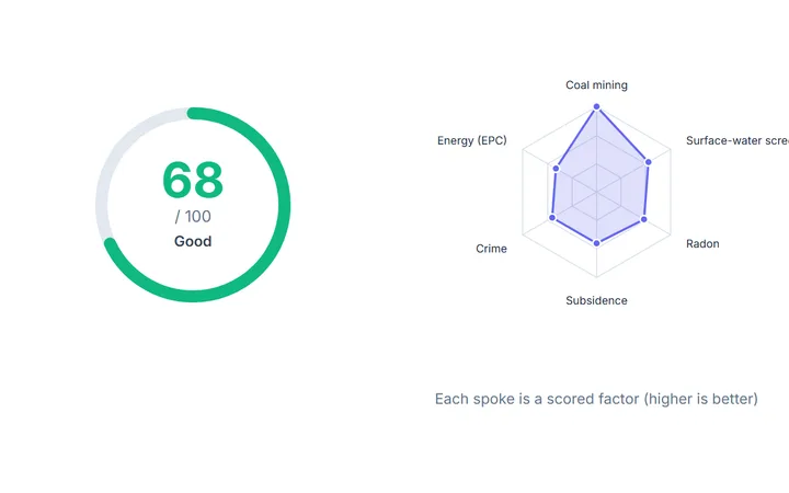 IQ Score and the factors behind it
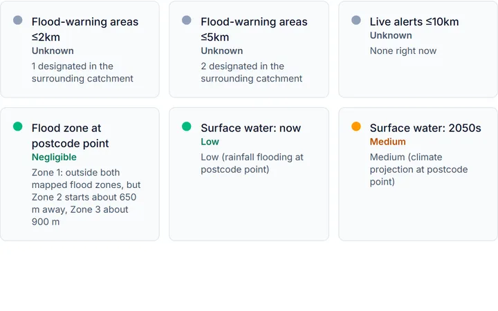 Flood risk at the postcode point
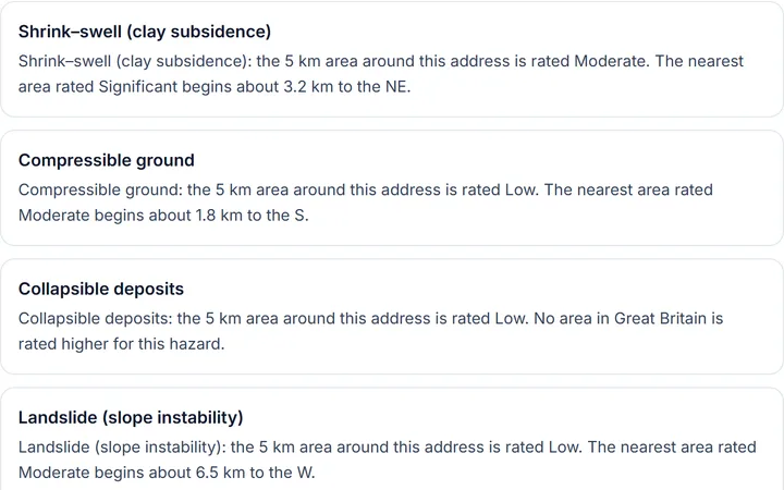 Six ground hazards, rated for the area
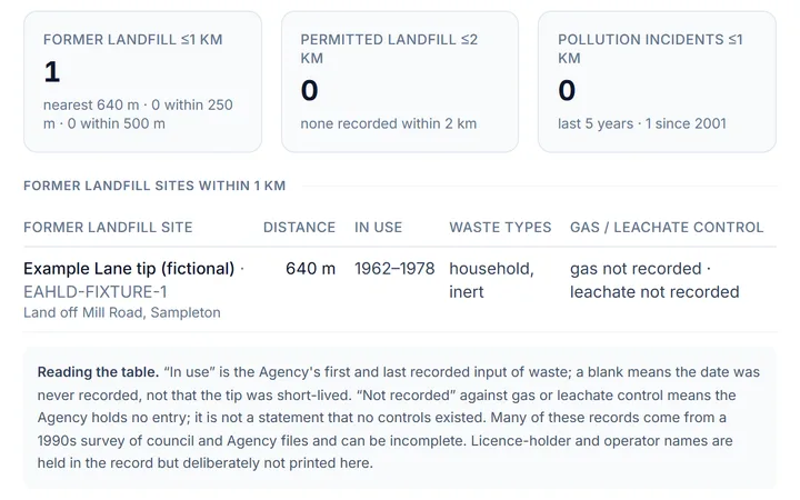 Landfill, permits and incidents nearby
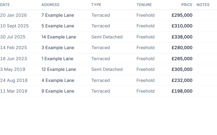 What homes here sold for
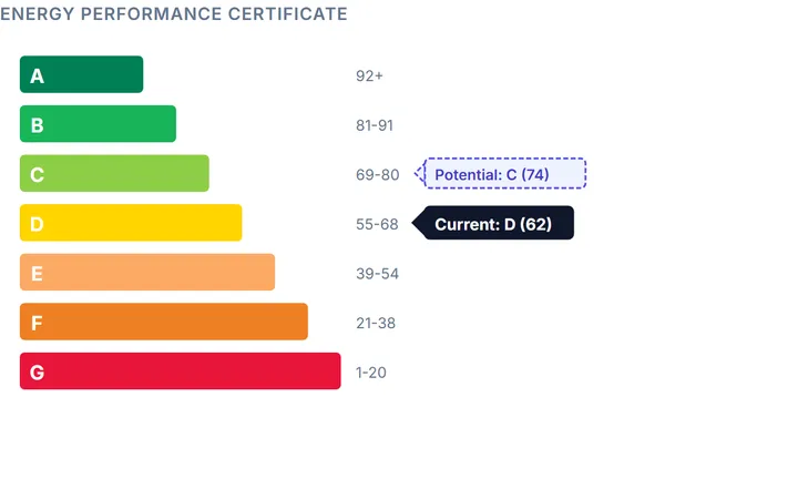 The energy rating, now and after upgrades
Illustrative sample · fictional address · cut from the sample report as it prints
Quick answer
Free street-check directories compile census, crime, house-price and broadband statistics for a street or postcode area. They are good for choosing an area and they describe everyone on the street, not the house you are buying: usually no flood zone at the address, no ground rating, no interpretation of the home's EPC or sale history, and nothing about what was not found. An address-level report starts where they stop.
| Dimension | Free street / area directory | Our free street check (below) | HouseCheckup Complete (£24.99) |
|---|---|---|---|
| Unit of analysis | A street, postcode or census output area | The postcode and its immediate area, labelled as such | One address |
| Who lives here | Census 2021 demographics for the area | Not included | Every census category with count and share, including household tenure |
| Crime | Area crime statistics, typically from police.uk | A crime rate per 1,000 residents for the neighbourhood, compared with England and Wales, plus a 12-month trend, levels by category and the busiest streets within half a mile, from police.uk | 24 months of incidents within a mile, by category, with the six-month change |
| House prices | Street or area averages, typically from HM Land Registry | What homes at this postcode actually sold for, with the median, from HM Land Registry Price Paid | Every recorded sale on the street with tenure and new-build flags, plus area averages by type |
| Flood | Usually not included | The official flood-risk band at the postcode point, rivers and the sea plus surface water (Environment Agency, NRW or SEPA) | Mapped zone, surface water now and 2050s, named warning areas, recorded events, climate allowances, Flood Re; Every asset within about 1.5 km with condition, maintainer and last inspection |
| Ground and subsidence | Not included | Not included (see the subsidence checker) | Coal, clay shrink-swell to the 2070s, landslide records, radon band and ground level; Six natural hazards plus non-coal mining, with distance to the nearest higher-rated cell |
| Energy (EPC) | Sometimes an area band mix | EPC band mix for the postcode, from the register | The whole certificate: every rated element, costs now and after, every costed improvement |
| Planning and heritage | Not included | Not included | Conservation areas and every listed building within 700 m, with grade and distance; Green belt to brownfield register: every designation that shapes what can be built |
| Schools, transport, noise, broadband | Nearby schools and Ofcom broadband speeds are common | Not included | Every school within 4 km with phase, grade and distance; Stations with lines, and every stop within 800 m; Road-traffic noise band, counted roads with HGV share, mapped hotspots; Predicted speeds and four-network indoor signal where published, or the check to run |
| Checks that returned nothing | Usually not shown | Shown as an honest gap with the official place to check | Named rather than scored as a pass, section by section |
| Price | Free | Free | £24.99, one-off |
Our verdict
Use a street directory, or the free check below, to decide which streets to look at. Both are the right tool for that, and both are free. Then stop treating the street as the unit. The things that go wrong in a purchase are house-level: the flood zone at the address, the clay under it, the EPC that was never updated, the sale history nobody mentioned. Those are what the £24.99 Complete report is for, and it keeps the area picture too.
Found the street? Check the house.
£24.99 Complete, one-off. 33 sections for one address, from the hazard screen to the surveyor's questions, with every check that could not be run named.
Type the full address with its postcode to go straight to your report options. Try .
£24.99 one-off · no subscription · Human-checked and emailed to you. See a sample report · Review report options and coverage
Cancel for a full refund at any time before your report is emailed. Terms
Run the free street check
The same kind of area read a directory gives you, with the source and the resolution under every number. Type the street's postcode:
Example: SE22 0AT, data as of 17 October 2026
What a street check shows, for one real postcode. Enter yours above for the same readings, plus the sections below the summary: people, housing, crime, schools and transport, flood and sold prices.
Street check: SE22 0AT · Southwark
Six headline readings for the street, each opening its own section in a full result. Crime rates are per resident, so town-centre neighbourhoods with few residents read high.
- Recorded crime6/10About average · higher than 57% of neighbourhoods
- Flood risk bandVery lowHighest of rivers & sea and surface water, at the postcode point
- Deprivation decile6 of 1010 = least deprived (England)
- Median sold price£747,500Last 12 recorded sales at this postcode
- Homes owned39%Of households, Census 2021
- Nearest station1.2 kmEast Dulwich Rail Station
Recorded crime, Peckham Rye Common
1 = among the lowest recorded-crime rates in England and Wales, 10 = among the highest. Each step is a tenth of all neighbourhoods.
6/10: higher than 57% of neighbourhoods in England and Wales
Who owns the homes (Census 2021)
Each home is a tenth of the households here. Biggest group: Private rented.
- Owned outright15%2 in 10England 33%
- Owned with a mortgage or loan23%2 in 10England 29%
- Shared ownership1%<1 in 10England 1%
- Social rented23%2 in 10England 17%
- Private rented39%4 in 10England 20%
- Lives rent free0%<1 in 10England <1%
Example: SE22 0AT, data as of 17 October 2026. Sources: police.uk, ONS Census 2021, the national deprivation index, the Environment Agency, HM Land Registry and NaPTAN. Figures change as sources update; run the check for today's readings.
What a street directory is good at
Choosing an area. The directories are built from the census, police.uk, HM Land Registry and Ofcom, and they turn those into a readable profile of a street: who lives there, what it sells for, how much crime is recorded, how fast the broadband is, which schools are near. For a buyer who does not know a town, that is a real service, and the good ones are free because the data is.
Where the street stops being the right unit
Everything that goes expensively wrong in a purchase is specific to the house. A street can be half in Flood Zone 3 and half out. One side can sit on London Clay rated Significant for shrink-swell and the other on gravel. Two identical terraces can have EPCs twenty years apart, one with a cavity-wall insulation note the survey will want to see. The sale history that matters is this property's, not the street average, and the planning label that matters is whether this building is in the conservation area, not whether the area has one. A street profile has no cell for any of that, and nowhere to record that a check was tried and returned nothing.
What the address-level report adds
The Complete report keeps the area picture (A plain-English picture of the place; Every census category with count and share, including household tenure; Walkability out of 100 and every everyday amenity counted, with the nearest named) and adds the layers a directory cannot hold: Mapped zone, surface water now and 2050s, named warning areas, recorded events, climate allowances, Flood Re; Coal, clay shrink-swell to the 2070s, landslide records, radon band and ground level; Former landfill within 1 km to its boundary, permitted landfill within 2 km, incidents, permits de-duplicated by site; Every recorded sale on the street with tenure and new-build flags, plus area averages by type; The whole certificate: every rated element, costs now and after, every costed improvement; Conservation areas and every listed building within 700 m, with grade and distance. It closes with A numbered brief built from what this address flagged and a before-you-offer checklist. Every section prints where the address has usable data, and a check that could not be run is named rather than scored as a pass. The full table of contents is on Lite vs Complete.
Reading any street statistic honestly
- Crime is snapped to anonymised map points and reflects footfall and reporting as much as offending; a busy high street records more than a cul-de-sac for that reason alone. Read the category mix and the trend, not the headline.
- Price averages mix flats, terraces and detached houses. The number that matters is what homes like the one you want sold for, and when, which is why the report prints every recorded sale with its type and tenure.
- Census figures are from 2021 and describe an output area of roughly a hundred and twenty-five households, not your prospective neighbours.
- Broadband speeds are predicted for the premises, not measured; a line to the exchange can be long on a short street.
From the street to the front door.
The area picture you already have, plus the house-level layers a street profile leaves out. £24.99, no subscription.
Type the full address with its postcode to go straight to your report options. Try .
£24.99 one-off · no subscription · Human-checked and emailed to you. See a sample report · Review report options and coverage
Sources
- Street-level crime data, data.police.uk (Home Office)
- Price Paid Data, HM Land Registry
- Census 2021, Office for National Statistics
- Check your long term flood risk, Environment Agency (GOV.UK)
- Flood warning areas, Environment Agency
- Find an energy certificate, GOV.UK
- Broadband and mobile coverage checker, Ofcom
How HouseCheckup works
From search to full report in three simple steps.
- England, Wales & Scotland
Search any address
Enter an address in England, Wales and Scotland. Coverage varies by nation and source.
- Before you pay
See the IQ Score
See an initial area risk screen where enough data is available, with the checks and coverage behind the score.
- Emailed within 24 hours
Get the full report
Choose Lite (£9.99) or Complete (£24.99). The report is emailed to you within 24 hours, usually faster, with every source named and any check it could not run stated.
Frequently asked questions
What do street check websites actually show?
Are street check sites accurate?
What does our free street check show?
What does the address-level report add?
Which is better for choosing an area?
Do street check sites cover Scotland and Wales?
Still have a question? We typically respond within 24 hours.
Ready to check a property?
Enter the address you are thinking of buying. See the available area risk data, then choose an emailed report for the property.
Type the full address with its postcode to go straight to your report options. Try .
Reports from £9.99, one-off. Compare Lite and Complete
Cancel for a full refund at any time before your report is emailed. Terms
At a glance
One-off
No subscription
Pay once for each report you buy.
Named
Sources & coverage
Every report names its sources and the checks it could not run.
GB
England, Wales & Scotland
Coverage varies by nation and source, and is stated.
£9.99
Reports from
Lite £9.99, Complete £24.99.